Two Types, Very Different Risk Levels
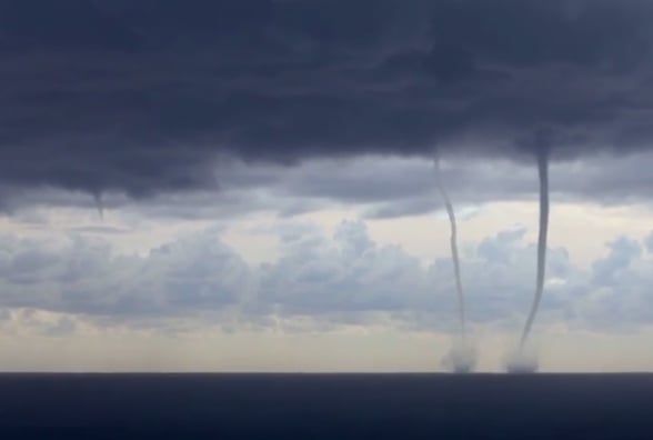
Waterspouts fall into two distinct categories, and scientists treat them as fundamentally different phenomena despite their similar appearance. Tornadic waterspouts are, in the plainest terms, land tornadoes that happen to form over water. They develop inside severe thunderstorms and carry the same destructive energy as their onshore counterparts. Fair-weather waterspouts, by contrast, form under relatively calm conditions and pose little real danger under most circumstances. The two types develop through different physical processes, reach different intensities, and behave differently once they form. Lumping them together because they look alike is a bit like calling a bonfire and a candle flame the same thing because both produce light.
Why Tornadic Waterspouts Demand Respect
Tornadic waterspouts form when air inside a severe thunderstorm begins rising rapidly and rotating around a vertical axis. As that rotation tightens and the column stretches downward toward the water, it becomes a fully developed waterspout carrying the same physics as a land tornado. National Geographic describes them as the most powerful and destructive type of waterspout, and the surrounding conditions typically make them more hazardous still. They arrive paired with high seas, large hail, and frequent lightning, turning the area around them into a genuinely dangerous environment for any vessel caught nearby. Unlike their fair-weather cousins, tornadic waterspouts can travel significant distances, maintaining their strength for as long as the parent storm sustains them.
How a Fair-Weather Waterspout Actually Builds
Fair-weather waterspouts follow a different and somewhat counterintuitive path. Rather than descending from a violent storm system, they build upward from the sea surface toward the cloud base above. The process begins when a developing cumulus cloud creates a zone of rising warm air. Near the water, that rising motion can trigger a rotating updraft, and under the right conditions that rotation organizes itself into a visible funnel climbing from the sea toward the sky. The cloud responsible is typically slow-moving and relatively modest in size, not the towering cumulonimbus associated with severe storms. This bottom-up formation process is one of the clearest physical distinctions between the two types and explains why fair-weather waterspouts tend to be weaker and shorter-lived.